
Munro Hillwalk - East and West Meur Gorm Craig
- Distance: 30.7 Km
- Elevation gain: 916 m
- Maximum elevation: 1,021 m
- Elevation loss: 916 m
- Minimum elevation: 400 m
- Moving time: 5 h 34 m
- Moving speed: 5.5 Km/h
- Maximum speed: 32.9 Km/h
- Total time: 6 h 10 m
- Global speed: 5.0 Km/h
Interactive trail map
Trail profile
- Distance: 30.7 Km
- Elevation gain: 916 m
- Maximum elevation: 1,021 m
- Elevation loss: 916 m
- Minimum elevation: 400 m
- Moving time: 5 h 34 m
- Moving speed: 5.5 Km/h
- Maximum speed: 32.9 Km/h
- Total time: 6 h 10 m
- Global speed: 5.0 Km/h
About this trail
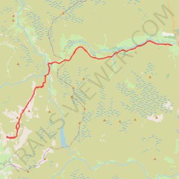
Name: Munro Hillwalk - East and West Meur Gorm Craig trail, distance, elevation, map, profile, GPS track
Start: A939, Cock Bridge, Aberdeenshire, Scotland, AB36 8YP, United Kingdom (57.16522 -3.23495)
End: A939, Cock Bridge, Aberdeenshire, Scotland, AB36 8YP, United Kingdom (57.16519 -3.23495)
Coordinates: 57.11491 -3.39955 57.16751 -3.23495