Thank you for supporting this site ❤️
Make a donation
Make a donation
Gear up for your next adventure:
As an Amazon Associate, this site earns from qualifying purchases at no extra cost to you.
Insta360 GPS Data
- Distance: 2.5 Km
- Elevation gain: 20 m
- Maximum elevation: 110 m
- Elevation loss: 14 m
- Minimum elevation: 102 m
- Moving time: 6 m 39 s
- Moving speed: 22.1 Km/h
- Maximum speed: 22.5 Km/h
- Total time: 6 m 39 s
- Global speed: 22.1 Km/h
Interactive trail map
Thank you for supporting this site ❤️
Make a donation
Make a donation
Gear up for your next adventure:
As an Amazon Associate, this site earns from qualifying purchases at no extra cost to you.
Trail profile
- Distance: 2.5 Km
- Elevation gain: 20 m
- Maximum elevation: 110 m
- Elevation loss: 14 m
- Minimum elevation: 102 m
- Moving time: 6 m 39 s
- Moving speed: 22.1 Km/h
- Maximum speed: 22.5 Km/h
- Total time: 6 m 39 s
- Global speed: 22.1 Km/h
Thank you for supporting this site ❤️
Make a donation
Make a donation
Gear up for your next adventure:
As an Amazon Associate, this site earns from qualifying purchases at no extra cost to you.
About this trail
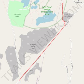
Name: Insta360 GPS Data trail, distance, elevation, map, profile, GPS track
Start: Tyler’s Pond Access Trail, Augusta, Kennebec County, Maine, United States (44.38853 -69.81893)
End: Summerhaven Road, Manchester, Kennebec County, Maine, 04351, United States (44.37068 -69.83299)
Coordinates: 44.37068 -69.83299 44.38853 -69.81815
Thank you for supporting this site ❤️
Make a donation
Make a donation
Gear up for your next adventure:
As an Amazon Associate, this site earns from qualifying purchases at no extra cost to you.