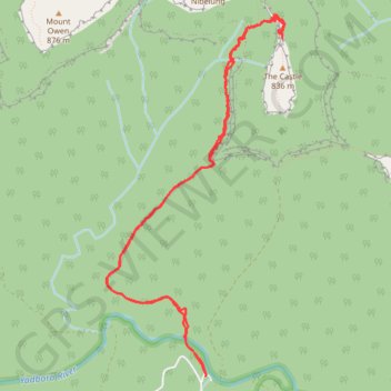
Long Gully - The Castle
Interactive trail map
Trail profile
- Distance: 13.0 Km
- Elevation gain: 1,212 m
- Maximum elevation: 705 m
- Elevation loss: 1,212 m
- Minimum elevation: 76 m
About this trail
Name: Long Gully - The Castle trail, distance, elevation, map, profile, GPS track
End: Yadboro, Shoalhaven City Council, New South Wales, 2539, Australia (-35.32090 150.19125)
Coordinates: -35.32090 150.18053 -35.28889 150.19984
Topography: New South Wales topographic map, elevation, terrain
Other hiking, mountain biking, running and outdoor activity trails
Click on a trail to view its statistics, map and profile.
Byangee Mountain and Pickering Point - Morton National Park
Distance: 18.0 Km • Elevation gain: 1,560 m • Maximum elevation: 515 m
Castle Walking Track and Castle to Monolith Valley
Distance: 15.5 Km • Elevation gain: 1,282 m • Maximum elevation: 852 m