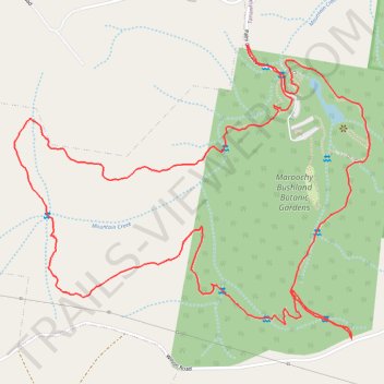
Maroochy Bushland Botanic Gardens Loop
- Distance: 6.4 Km
- Elevation gain: 130 m
- Maximum elevation: 81 m
- Elevation loss: 130 m
- Minimum elevation: 28 m
- Moving time: 49 m 37 s
- Moving speed: 7.7 Km/h
- Maximum speed: 15.7 Km/h
- Total time: 49 m 37 s
- Global speed: 7.7 Km/h
Interactive trail map
Trail profile
- Distance: 6.4 Km
- Elevation gain: 130 m
- Maximum elevation: 81 m
- Elevation loss: 130 m
- Minimum elevation: 28 m
- Moving time: 49 m 37 s
- Moving speed: 7.7 Km/h
- Maximum speed: 15.7 Km/h
- Total time: 49 m 37 s
- Global speed: 7.7 Km/h
About this trail
Name: Maroochy Bushland Botanic Gardens Loop trail, distance, elevation, map, profile, GPS track
Start: Palm Creek Road, Sunshine Coast Regional, Queensland, 4554, Australia (-26.71668 153.02170)
End: Palm Creek Road, Sunshine Coast Regional, Queensland, 4554, Australia (-26.71668 153.02175)
Coordinates: -26.72663 153.01288 -26.71668 153.02636
Topography: Sunshine Coast Regional topographic map, elevation, terrain