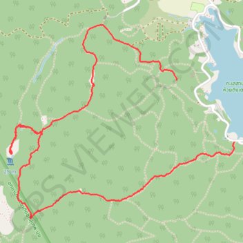
Mae Rim Hiking
- Distance: 6.6 Km
- Elevation gain: 471 m
- Maximum elevation: 772 m
- Elevation loss: 486 m
- Minimum elevation: 357 m
- Moving time: 7 d 2 h
- Moving speed: 0.0 Km/h
- Maximum speed: 10.3 Km/h
- Total time: 7 d 3 h
- Global speed: 0.0 Km/h
Interactive trail map
Trail profile
- Distance: 6.6 Km
- Elevation gain: 471 m
- Maximum elevation: 772 m
- Elevation loss: 486 m
- Minimum elevation: 357 m
- Moving time: 7 d 2 h
- Moving speed: 0.0 Km/h
- Maximum speed: 10.3 Km/h
- Total time: 7 d 3 h
- Global speed: 0.0 Km/h
About this trail
Name: Mae Rim Hiking trail, distance, elevation, map, profile, GPS track
Start: Ban Huai Tueng Thao, Chiang Mai, Mae Raem, Chiang Mai Province, 50180, Thailand (18.86754 98.93553)
Coordinates: 18.85729 98.92238 18.87169 98.94001