Import a GPX file

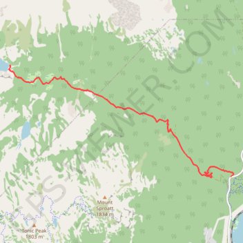
Whistler - Rainbow Lake

#Hiking

  • Distance: 8.4 Km
  • Elevation gain: 831 m
  • Maximum elevation: 1,459 m
  • Elevation loss: 51 m
  • Minimum elevation: 675 m

Interactive trail map

Trail profile

  • Distance: 8.4 Km
  • Elevation gain: 831 m
  • Maximum elevation: 1,459 m
  • Elevation loss: 51 m
  • Minimum elevation: 675 m

About this trail

Other hiking, mountain biking, running and outdoor activity trails

Click on a trail to view its statistics, map and profile.

Cheakamus River and Lillooet River

Canada > British Columbia > Squamish-Lillooet Regional District > Area D (Elaho/Garibaldi)

Bikepack from Daisy Lake along Cheakamus River and Lillooet River via Alta Lake, Whistler, Green Lake, Shadow Lake, Nairn Falls, One Mile Lake and Pemberton. #Bike #Nature #River #Lake #Mountain #Forest

Distance: 84.6 Km • Elevation gain: 1,233 m • Maximum elevation: 754 m

Vancouver - Golden

Canada > British Columbia > Metro Vancouver Regional District > Vancouver

#Bike #Vancouver #Golden

Distance: 827.6 Km • Elevation gain: 9,376 m • Maximum elevation: 1,347 m

Gear up for your next adventure:

🕯️Emergency Whistles - Safety whistles for hiking
🥤Outdoor Water Bottles - Reusable bottles for outdoor activities
🧰Survival Kits - Essential survival gear
Outdoor Coffee Makers - Enjoy quality coffee at the summit of your favorite peak
🥾Heavy Duty Hiking Boots - Ankle-supporting boots for carrying heavy packs on steep contours

As an Amazon Associate, this site earns from qualifying purchases at no extra cost to you.