Nordic backcountry ski on Into Woods trail
Backcountry ski via Into Woods, Woods Lake, Out of Woods, Howe It Goes and Madeley Lake FSR in the Coast Mountains. #Ski #Mountain #Nature #Forest #Lake
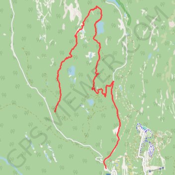
- Distance: 11.2 Km
- Elevation gain: 259 m
- Maximum elevation: 1,168 m
- Elevation loss: 557 m
- Minimum elevation: 812 m
- Moving time: 2 h 31 m
- Moving speed: 4.4 Km/h
- Maximum speed: 33.5 Km/h
- Total time: 3 h 48 m
- Global speed: 2.9 Km/h
Interactive trail map
Trail profile
- Distance: 11.2 Km
- Elevation gain: 259 m
- Maximum elevation: 1,168 m
- Elevation loss: 557 m
- Minimum elevation: 812 m
- Moving time: 2 h 31 m
- Moving speed: 4.4 Km/h
- Maximum speed: 33.5 Km/h
- Total time: 3 h 48 m
- Global speed: 2.9 Km/h
About this trail
Name: Nordic backcountry ski on Into Woods trail trail, distance, elevation, map, profile, GPS track
Coordinates: 50.13696 -123.14910 50.17667 -123.12405
Other hiking, mountain biking, running and outdoor activity trails
Click on a trail to view its statistics, map and profile.
Loop trail around Madeley Lake
Canada > British Columbia > Squamish-Lillooet Regional District > Area D (Elaho/Garibaldi)
Distance: 6.1 Km • Elevation gain: 147 m • Maximum elevation: 1,047 m