Thank you for supporting this site ❤️
Make a donation
Make a donation
Gear up for your next adventure:
As an Amazon Associate, this site earns from qualifying purchases at no extra cost to you.
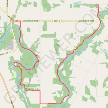
Little Lakes - Benmiller
Maitland River. #Hiking
- Distance: 20.3 Km
- Elevation gain: 295 m
- Maximum elevation: 289 m
- Elevation loss: 323 m
- Minimum elevation: 224 m
Interactive trail map
Thank you for supporting this site ❤️
Make a donation
Make a donation
Gear up for your next adventure:
As an Amazon Associate, this site earns from qualifying purchases at no extra cost to you.
Trail profile
- Distance: 20.3 Km
- Elevation gain: 295 m
- Maximum elevation: 289 m
- Elevation loss: 323 m
- Minimum elevation: 224 m
Thank you for supporting this site ❤️
Make a donation
Make a donation
Gear up for your next adventure:
As an Amazon Associate, this site earns from qualifying purchases at no extra cost to you.
About this trail
Name: Little Lakes - Benmiller trail, distance, elevation, map, profile, GPS track
Coordinates: 43.67554 -81.62929 43.73090 -81.55816
Thank you for supporting this site ❤️
Make a donation
Make a donation
Gear up for your next adventure:
As an Amazon Associate, this site earns from qualifying purchases at no extra cost to you.