Import a GPX file
👉 Easily get elevation data in JSON, GeoTIFF and KML formats using Elevation API
Thank you for supporting this site ❤️
Make a donation

Gear up for your next adventure:

As an Amazon Associate, this site earns from qualifying purchases at no extra cost to you.

Whistler - Blackcomb Mountain

#Hiking #Loop #Whistler #Blackcomb

  • Distance: 9.1 Km
  • Elevation gain: 436 m
  • Maximum elevation: 1,142 m
  • Elevation loss: 434 m
  • Minimum elevation: 760 m

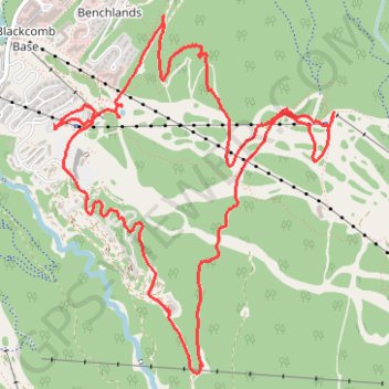
Interactive trail map

Trail profile

  • Distance: 9.1 Km
  • Elevation gain: 436 m
  • Maximum elevation: 1,142 m
  • Elevation loss: 434 m
  • Minimum elevation: 760 m

About this trail

Other hiking, mountain biking, running and outdoor activity trails

Click on a trail to view its statistics, map and profile.

Cheakamus River and Lillooet River

Canada > British Columbia > Squamish-Lillooet Regional District > Area D (Elaho/Garibaldi)

Bikepack from Daisy Lake along Cheakamus River and Lillooet River via Alta Lake, Whistler, Green Lake, Shadow Lake, Nairn Falls, One Mile Lake and Pemberton. #Bike #Nature #River #Lake #Mountain #Forest

Distance: 84.6 Km • Elevation gain: 1,233 m • Maximum elevation: 754 m

Vancouver - Golden

Canada > British Columbia > Metro Vancouver Regional District > Vancouver

#Bike #Vancouver #Golden

Distance: 827.6 Km • Elevation gain: 9,376 m • Maximum elevation: 1,347 m

Gear up for your next adventure:

🪫Rechargeable Headlamps - USB rechargeable headlamps
Outdoor Coffee Makers - Enjoy quality coffee at the summit of your favorite peak
🧴SPF 50+ Bulk Sunscreen - Maximum protection for long-term outdoor exposure
🔪Camping Knives - Multi-purpose outdoor knives
🧥Softshell Jackets - Flexible outdoor jackets

As an Amazon Associate, this site earns from qualifying purchases at no extra cost to you.