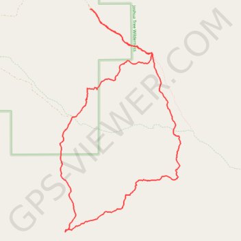
Covington Loop (Joshua Tree National Park)
Interactive trail map
Trail profile
- Distance: 13.6 Km
- Elevation gain: 303 m
- Maximum elevation: 1,558 m
- Elevation loss: 303 m
- Minimum elevation: 1,364 m
About this trail
Name: Covington Loop (Joshua Tree National Park) trail, distance, elevation, map, profile, GPS track
Start: Trail, Riverside County, California, United States (34.02774 -116.30229)
End: Trail, Riverside County, California, United States (34.02769 -116.30220)
Coordinates: 33.99037 -116.30836 34.02774 -116.28396
Other hiking, mountain biking, running and outdoor activity trails
Click on a trail to view its statistics, map and profile.