Import a GPX file

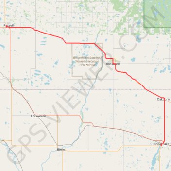
Russell - Shoal Lake

#Bike #Russell #Shoal

  • Distance: 77.6 Km
  • Elevation gain: 164 m
  • Maximum elevation: 599 m
  • Elevation loss: 167 m
  • Minimum elevation: 517 m

Interactive trail map

Trail profile

  • Distance: 77.6 Km
  • Elevation gain: 164 m
  • Maximum elevation: 599 m
  • Elevation loss: 167 m
  • Minimum elevation: 517 m

About this trail

Other hiking, mountain biking, running and outdoor activity trails

Click on a trail to view its statistics, map and profile.

Yorkton - Russell

Canada > Saskatchewan > Yorkton

#Bike #Yorkton #Russell

Distance: 105.1 Km • Elevation gain: 235 m • Maximum elevation: 565 m

Shoal Lake - Neepawa

Canada > Rural Municipality of Yellowhead > Shoal Lake

#Bike #Shoal #Neepawa

Distance: 96.6 Km • Elevation gain: 203 m • Maximum elevation: 609 m

Gear up for your next adventure:

🎒Dry Bags - Waterproof bags for outdoor gear
🗺️Topographic Maps - Detailed maps for hiking and navigation
🏃Compression Recovery Socks - Reduce leg fatigue after heavy days of elevation gain
🛰️Handheld GPS Units - Rugged GPS devices for tracking coordinates and elevation in the Australian bush
🦟Insect Repellent - Protection against insects

As an Amazon Associate, this site earns from qualifying purchases at no extra cost to you.