Mount Erica and Talbot Hut Ruins
Hike to Mount Erica and Talbot Hut Ruins via Australian Alps Walking Track, Overhanging Rock and Mushroom Rock in the Baw Baw National Park. #Hiking #Mountain #Nature #Forest #Rock #Park
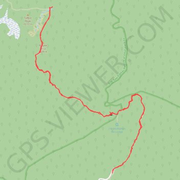
- Distance: 10.1 Km
- Elevation gain: 463 m
- Maximum elevation: 1,491 m
- Elevation loss: 469 m
- Minimum elevation: 1,085 m
- Moving time: 3 h 5 m
- Moving speed: 3.3 Km/h
- Maximum speed: 5.7 Km/h
- Total time: 3 h 47 m
- Global speed: 2.7 Km/h
Interactive trail map
Trail profile
- Distance: 10.1 Km
- Elevation gain: 463 m
- Maximum elevation: 1,491 m
- Elevation loss: 469 m
- Minimum elevation: 1,085 m
- Moving time: 3 h 5 m
- Moving speed: 3.3 Km/h
- Maximum speed: 5.7 Km/h
- Total time: 3 h 47 m
- Global speed: 2.7 Km/h
About this trail
Name: Mount Erica and Talbot Hut Ruins trail, distance, elevation, map, profile, GPS track
Start: Mt Erica Road, Baw Baw, Shire of Baw Baw, Victoria, 3825, Australia (-37.89266 146.35520)
End: Mt Erica Road, Baw Baw, Shire of Baw Baw, Victoria, 3825, Australia (-37.89296 146.35516)
Coordinates: -37.89296 146.34264 -37.87150 146.36046
Topography: Victoria topographic map, elevation, terrain
Other hiking, mountain biking, running and outdoor activity trails
Click on a trail to view its statistics, map and profile.
Traralgon - Walhalla - Woods Point
Australia > Victoria > Traralgon
#Bike
Distance: 124.6 Km • Elevation gain: 4,258 m • Maximum elevation: 1,165 m
Moe - Woods Point
#Bike
Distance: 109.2 Km • Elevation gain: 3,295 m • Maximum elevation: 1,165 m