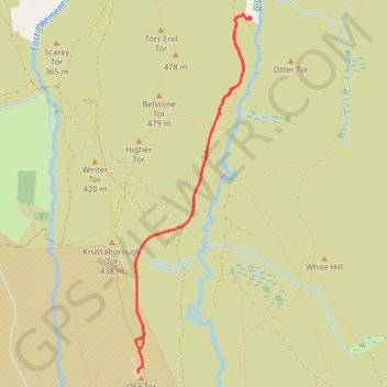
Bernard's Acre to Oke Tor
Interactive trail map
Trail profile
- Distance: 6.5 Km
- Elevation gain: 142 m
- Maximum elevation: 455 m
- Elevation loss: 149 m
- Minimum elevation: 324 m
- Moving time: 1 h 37 m
- Moving speed: 4.0 Km/h
- Maximum speed: 6.2 Km/h
- Total time: 1 h 54 m
- Global speed: 3.4 Km/h
About this trail
Name: Bernard's Acre to Oke Tor trail, distance, elevation, map, profile, GPS track
Start: Taikoo driveway, Belstone, West Devon, Devon, England, EX20 1QZ, United Kingdom (50.71691 -3.95471)
End: Taikoo driveway, Belstone, West Devon, Devon, England, EX20 1QZ, United Kingdom (50.71671 -3.95405)
Coordinates: 50.69310 -3.96617 50.71695 -3.95395