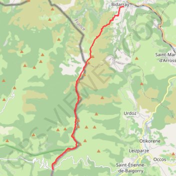
J1 V.Classique
- Distance: 13.0 Km
- Elevation gain: 688 m
- Maximum elevation: 1,013 m
- Elevation loss: 1,217 m
- Minimum elevation: 134 m
- Moving time: 3 h 49 m
- Moving speed: 3.4 Km/h
- Maximum speed: 15.0 Km/h
- Total time: 3 h 52 m
- Global speed: 3.4 Km/h
Interactive trail map
Trail profile
- Distance: 13.0 Km
- Elevation gain: 688 m
- Maximum elevation: 1,013 m
- Elevation loss: 1,217 m
- Minimum elevation: 134 m
- Moving time: 3 h 49 m
- Moving speed: 3.4 Km/h
- Maximum speed: 15.0 Km/h
- Total time: 3 h 52 m
- Global speed: 3.4 Km/h
About this trail
Name: J1 V.Classique trail, distance, elevation, map, profile, GPS track
Coordinates: 43.17556 -1.40242 43.26561 -1.34829
Other hiking, mountain biking, running and outdoor activity trails
Click on a trail to view its statistics, map and profile.
Day 1 - Hendaye to St. Jean Pied de Port
France > Nouvelle-Aquitaine > Pyrénées-Atlantiques > Hendaye
Distance: 77.1 Km • Elevation gain: 2,065 m • Maximum elevation: 373 m
GR 10 - Traversée des Pyrénées
France > Occitania > Pyrénées-Orientales > Banyuls-sur-Mer
Distance: 874.8 Km • Elevation gain: 57,000 m • Maximum elevation: 2,599 m
1 LUCENA - MONTPELLIER
Distance: 2,964.4 Km • Elevation gain: 29,500 m • Maximum elevation: 1,048 m
Southern section — European Divide Trail
France > Auvergne-Rhône-Alpes > Drôme > Valence
Distance: 2,423.8 Km • Elevation gain: 42,375 m • Maximum elevation: 2,005 m