Thank you for supporting this site ❤️
Make a donation
Make a donation
Gear up for your next adventure:
As an Amazon Associate, this site earns from qualifying purchases at no extra cost to you.
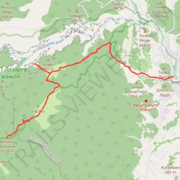
Malinik, Lazrev kanjon, 5.7.2014.
- Distance: 20.3 Km
- Elevation gain: 995 m
- Maximum elevation: 1,148 m
- Elevation loss: 994 m
- Minimum elevation: 268 m
- Moving time: 5 h 46 m
- Moving speed: 3.5 Km/h
- Maximum speed: 8.0 Km/h
- Total time: 8 h 13 m
- Global speed: 2.5 Km/h
Interactive trail map
Thank you for supporting this site ❤️
Make a donation
Make a donation
Gear up for your next adventure:
As an Amazon Associate, this site earns from qualifying purchases at no extra cost to you.
Trail profile
- Distance: 20.3 Km
- Elevation gain: 995 m
- Maximum elevation: 1,148 m
- Elevation loss: 994 m
- Minimum elevation: 268 m
- Moving time: 5 h 46 m
- Moving speed: 3.5 Km/h
- Maximum speed: 8.0 Km/h
- Total time: 8 h 13 m
- Global speed: 2.5 Km/h
Thank you for supporting this site ❤️
Make a donation
Make a donation
Gear up for your next adventure:
As an Amazon Associate, this site earns from qualifying purchases at no extra cost to you.
About this trail
Name: Malinik, Lazrev kanjon, 5.7.2014. trail, distance, elevation, map, profile, GPS track
Coordinates: 43.99183 21.91210 44.02143 21.98454
Thank you for supporting this site ❤️
Make a donation
Make a donation
Gear up for your next adventure:
As an Amazon Associate, this site earns from qualifying purchases at no extra cost to you.
Other hiking, mountain biking, running and outdoor activity trails
Click on a trail to view its statistics, map and profile.
2022_Yu
Slovenia > Ajdovščina > Žapuže
Distance: 2,457.3 Km • Elevation gain: 32,048 m • Maximum elevation: 1,950 m