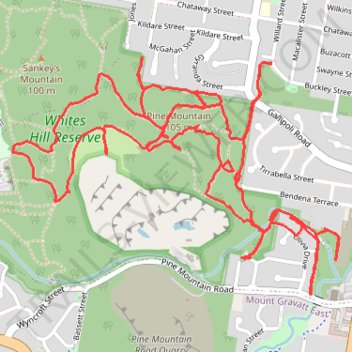
Whites Hill Trail Run
- Distance: 10.2 Km
- Elevation gain: 230 m
- Maximum elevation: 99 m
- Elevation loss: 230 m
- Minimum elevation: 20 m
- Moving time: 1 h 29 m
- Moving speed: 6.8 Km/h
- Maximum speed: 12.3 Km/h
- Total time: 1 h 32 m
- Global speed: 6.6 Km/h
Interactive trail map
Trail profile
- Distance: 10.2 Km
- Elevation gain: 230 m
- Maximum elevation: 99 m
- Elevation loss: 230 m
- Minimum elevation: 20 m
- Moving time: 1 h 29 m
- Moving speed: 6.8 Km/h
- Maximum speed: 12.3 Km/h
- Total time: 1 h 32 m
- Global speed: 6.6 Km/h
About this trail
Name: Whites Hill Trail Run trail, distance, elevation, map, profile, GPS track
Coordinates: -27.51726 153.08146 -27.50761 153.09636
Topography: City of Brisbane topographic map, elevation, terrain
Other hiking, mountain biking, running and outdoor activity trails
Click on a trail to view its statistics, map and profile.
Brisbane - Karawatha
Distance: 22.2 Km • Elevation gain: 239 m • Maximum elevation: 89 m