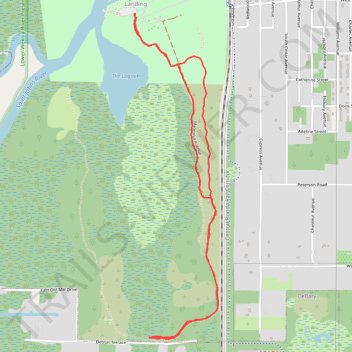
Pine Island Trail at Blue Springs State Park, Orange City, FL
- Distance: 6.8 Km
- Elevation gain: 36 m
- Maximum elevation: 16 m
- Elevation loss: 36 m
- Minimum elevation: 5 m
- Moving time: 1 h 40 m
- Moving speed: 4.1 Km/h
- Maximum speed: 5.2 Km/h
- Total time: 1 h 49 m
- Global speed: 3.7 Km/h
Interactive trail map
Trail profile
- Distance: 6.8 Km
- Elevation gain: 36 m
- Maximum elevation: 16 m
- Elevation loss: 36 m
- Minimum elevation: 5 m
- Moving time: 1 h 40 m
- Moving speed: 4.1 Km/h
- Maximum speed: 5.2 Km/h
- Total time: 1 h 49 m
- Global speed: 3.7 Km/h
About this trail
Name: Pine Island Trail at Blue Springs State Park, Orange City, FL trail, distance, elevation, map, profile, GPS track
Coordinates: 28.91967 -81.33989 28.94237 -81.33322