Thank you for supporting this site ❤️
Make a donation
Make a donation
Gear up for your next adventure:
As an Amazon Associate, this site earns from qualifying purchases at no extra cost to you.
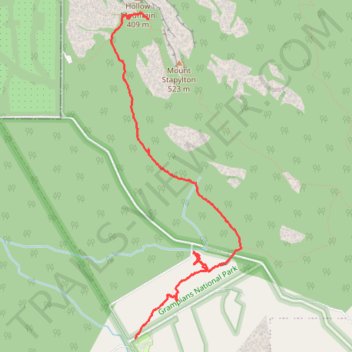
Mount Stapylton West
- Distance: 6.0 Km
- Elevation gain: 145 m
- Maximum elevation: 315 m
- Elevation loss: 82 m
- Minimum elevation: 245 m
- Moving time: 1 h 56 m
- Moving speed: 3.1 Km/h
- Maximum speed: 6.0 Km/h
- Total time: 3 h 35 m
- Global speed: 1.7 Km/h
Interactive trail map
Thank you for supporting this site ❤️
Make a donation
Make a donation
Gear up for your next adventure:
As an Amazon Associate, this site earns from qualifying purchases at no extra cost to you.
Trail profile
- Distance: 6.0 Km
- Elevation gain: 145 m
- Maximum elevation: 315 m
- Elevation loss: 82 m
- Minimum elevation: 245 m
- Moving time: 1 h 56 m
- Moving speed: 3.1 Km/h
- Maximum speed: 6.0 Km/h
- Total time: 3 h 35 m
- Global speed: 1.7 Km/h
Thank you for supporting this site ❤️
Make a donation
Make a donation
Gear up for your next adventure:
As an Amazon Associate, this site earns from qualifying purchases at no extra cost to you.
About this trail
Name: Mount Stapylton West trail, distance, elevation, map, profile, GPS track
Coordinates: -36.92304 142.37968 -36.89398 142.39416
Topography: Victoria topographic map, elevation, terrain
Thank you for supporting this site ❤️
Make a donation
Make a donation
Gear up for your next adventure:
As an Amazon Associate, this site earns from qualifying purchases at no extra cost to you.