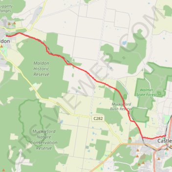
Maldon- Castlemaine Rail Trail
- Distance: 16.9 Km
- Elevation gain: 139 m
- Maximum elevation: 360 m
- Elevation loss: 215 m
- Minimum elevation: 274 m
- Moving time: 2 h 2 m
- Moving speed: 8.3 Km/h
- Maximum speed: 21.1 Km/h
- Total time: 2 h 2 m
- Global speed: 8.3 Km/h
Interactive trail map
Trail profile
- Distance: 16.9 Km
- Elevation gain: 139 m
- Maximum elevation: 360 m
- Elevation loss: 215 m
- Minimum elevation: 274 m
- Moving time: 2 h 2 m
- Moving speed: 8.3 Km/h
- Maximum speed: 21.1 Km/h
- Total time: 2 h 2 m
- Global speed: 8.3 Km/h
About this trail
Name: Maldon- Castlemaine Rail Trail trail, distance, elevation, map, profile, GPS track
Coordinates: -37.06537 144.07399 -36.99068 144.21425
Topography: Victoria topographic map, elevation, terrain
Other hiking, mountain biking, running and outdoor activity trails
Click on a trail to view its statistics, map and profile.
Goldfields Track - Castlemaine circuit
Australia > Victoria > Castlemaine
#MTB #Loop #Goldfields #Castlemaine
Distance: 16.8 Km • Elevation gain: 178 m • Maximum elevation: 382 m