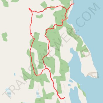
Laberge Trail Walk
- Distance: 7.2 Km
- Elevation gain: 79 m
- Maximum elevation: 671 m
- Elevation loss: 78 m
- Minimum elevation: 625 m
- Moving time: 1 h 37 m
- Moving speed: 4.4 Km/h
- Maximum speed: 8.2 Km/h
- Total time: 1 h 44 m
- Global speed: 4.2 Km/h
Interactive trail map
Trail profile
- Distance: 7.2 Km
- Elevation gain: 79 m
- Maximum elevation: 671 m
- Elevation loss: 78 m
- Minimum elevation: 625 m
- Moving time: 1 h 37 m
- Moving speed: 4.4 Km/h
- Maximum speed: 8.2 Km/h
- Total time: 1 h 44 m
- Global speed: 4.2 Km/h
About this trail
Name: Laberge Trail Walk trail, distance, elevation, map, profile, GPS track
Start: 102, Fossil Point Road, Yukon, Canada (61.08841 -135.20844)
End: 102, Fossil Point Road, Yukon, Canada (61.08841 -135.20864)
Coordinates: 61.08811 -135.22302 61.10677 -135.20477
Other hiking, mountain biking, running and outdoor activity trails
Click on a trail to view its statistics, map and profile.
Mt Bike Ride - Lake Laberge
Distance: 16.5 Km • Elevation gain: 218 m • Maximum elevation: 717 m
Laberge Mt Bike Ride
Distance: 18.7 Km • Elevation gain: 313 m • Maximum elevation: 736 m
Dog Leg on Outer Grazing Fence Trail
Distance: 0.8 Km • Elevation gain: 43 m • Maximum elevation: 680 m