Make a donation
Gear up for your next adventure:
As an Amazon Associate, this site earns from qualifying purchases at no extra cost to you.
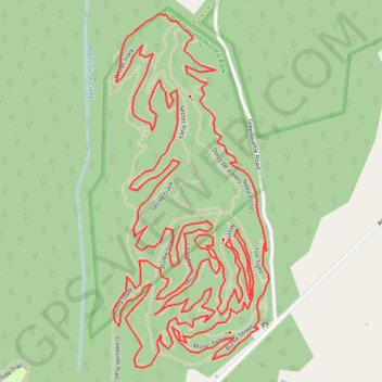
Beechworth Mountain Bike Circuit
Beechworth Historic Park. #MTB #Loop #Beechworth
- Distance: 8.3 Km
- Elevation gain: 231 m
- Maximum elevation: 583 m
- Elevation loss: 231 m
- Minimum elevation: 471 m
Interactive trail map
Make a donation
Gear up for your next adventure:
As an Amazon Associate, this site earns from qualifying purchases at no extra cost to you.
Trail profile
- Distance: 8.3 Km
- Elevation gain: 231 m
- Maximum elevation: 583 m
- Elevation loss: 231 m
- Minimum elevation: 471 m
Make a donation
Gear up for your next adventure:
As an Amazon Associate, this site earns from qualifying purchases at no extra cost to you.
About this trail
Name: Beechworth Mountain Bike Circuit trail, distance, elevation, map, profile, GPS track
Start: Burke Street, Beechworth, Shire of Indigo, Victoria, 3747, Australia (-36.34342 146.70596)
End: Burke Street, Beechworth, Shire of Indigo, Victoria, 3747, Australia (-36.34342 146.70596)
Coordinates: -36.34445 146.70154 -36.33551 146.70642
Topography: Victoria topographic map, elevation, terrain
Make a donation
Gear up for your next adventure:
As an Amazon Associate, this site earns from qualifying purchases at no extra cost to you.