Bucklers Park
- Distance: 7.9 Km
- Elevation gain: 49 m
- Maximum elevation: 101 m
- Elevation loss: 28 m
- Minimum elevation: 77 m
- Moving time: 1 h 33 m
- Moving speed: 5.1 Km/h
- Maximum speed: 11.7 Km/h
- Total time: 2 h 20 m
- Global speed: 3.4 Km/h
Interactive trail map
Trail profile
- Distance: 7.9 Km
- Elevation gain: 49 m
- Maximum elevation: 101 m
- Elevation loss: 28 m
- Minimum elevation: 77 m
- Moving time: 1 h 33 m
- Moving speed: 5.1 Km/h
- Maximum speed: 11.7 Km/h
- Total time: 2 h 20 m
- Global speed: 3.4 Km/h
About this trail
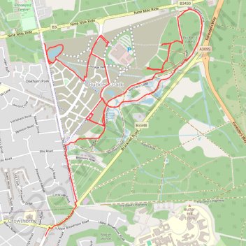
Name: Bucklers Park trail, distance, elevation, map, profile, GPS track
Coordinates: 51.36968 -0.79249 51.38612 -0.77423