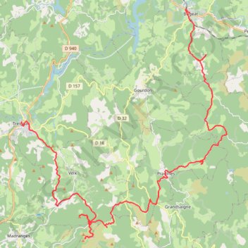
Parcours_suiveurs_2024
- Distance: 46.3 Km
- Elevation gain: 1,187 m
- Maximum elevation: 916 m
- Elevation loss: 972 m
- Minimum elevation: 481 m
- Moving time: 1 h 9 m
- Moving speed: 40.1 Km/h
- Maximum speed: 55.6 Km/h
- Total time: 1 h 9 m
- Global speed: 40.1 Km/h
Interactive trail map
Trail profile
- Distance: 46.3 Km
- Elevation gain: 1,187 m
- Maximum elevation: 916 m
- Elevation loss: 972 m
- Minimum elevation: 481 m
- Moving time: 1 h 9 m
- Moving speed: 40.1 Km/h
- Maximum speed: 55.6 Km/h
- Total time: 1 h 9 m
- Global speed: 40.1 Km/h
About this trail
Name: Parcours_suiveurs_2024 trail, distance, elevation, map, profile, GPS track
Coordinates: 45.47206 1.79364 45.59982 1.95697
Other hiking, mountain biking, running and outdoor activity trails
Click on a trail to view its statistics, map and profile.
Chemin de Saint-Jacques-de-Compostelle
Switzerland > Geneva > Geneva
Distance: 1,117.8 Km • Elevation gain: 25,262 m • Maximum elevation: 1,430 m
GR 654 - Le chemin vers Saint-Jacques-de-Compostelle via Vézelay
France > Nouvelle-Aquitaine > Dordogne > Bergerac
Distance: 810.9 Km • Elevation gain: 9,631 m • Maximum elevation: 670 m