Thank you for supporting this site ❤️
Make a donation
Make a donation
Gear up for your next adventure:
As an Amazon Associate, this site earns from qualifying purchases at no extra cost to you.
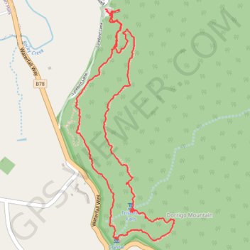
Tristania Falls - Crystal Shower Falls - Wonga Walk
Interactive trail map
Thank you for supporting this site ❤️
Make a donation
Make a donation
Gear up for your next adventure:
As an Amazon Associate, this site earns from qualifying purchases at no extra cost to you.
Trail profile
- Distance: 6.8 Km
- Elevation gain: 346 m
- Maximum elevation: 771 m
- Elevation loss: 341 m
- Minimum elevation: 602 m
- Moving time: 1 h 29 m
- Moving speed: 4.6 Km/h
- Maximum speed: 12.9 Km/h
- Total time: 1 h 31 m
- Global speed: 4.5 Km/h
Thank you for supporting this site ❤️
Make a donation
Make a donation
Gear up for your next adventure:
As an Amazon Associate, this site earns from qualifying purchases at no extra cost to you.
About this trail
Name: Tristania Falls - Crystal Shower Falls - Wonga Walk trail, distance, elevation, map, profile, GPS track
Coordinates: -30.38080 152.72600 -30.36351 152.73453
Topography: New South Wales topographic map, elevation, terrain
Thank you for supporting this site ❤️
Make a donation
Make a donation
Gear up for your next adventure:
As an Amazon Associate, this site earns from qualifying purchases at no extra cost to you.
Other hiking, mountain biking, running and outdoor activity trails
Click on a trail to view its statistics, map and profile.