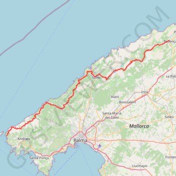
GR221 tramuntana
- Distance: 116.1 Km
- Elevation gain: 5,851 m
- Maximum elevation: 1,209 m
- Elevation loss: 5,903 m
- Minimum elevation: 6 m
Interactive trail map
Trail profile
- Distance: 116.1 Km
- Elevation gain: 5,851 m
- Maximum elevation: 1,209 m
- Elevation loss: 5,903 m
- Minimum elevation: 6 m
About this trail
Name: GR221 tramuntana trail, distance, elevation, map, profile, GPS track
Coordinates: 39.58387 2.35049 39.88209 3.01261
Other hiking, mountain biking, running and outdoor activity trails
Click on a trail to view its statistics, map and profile.
Southern section — European Divide Trail
France > Auvergne-Rhône-Alpes > Drôme > Valence
Distance: 2,423.8 Km • Elevation gain: 42,375 m • Maximum elevation: 2,005 m
GR221 tramuntana
Spain > Balearic Islands > Serra de Tramuntana > Pollença
Distance: 116.1 Km • Elevation gain: 5,851 m • Maximum elevation: 1,209 m
1 LUCENA - MONTPELLIER
Distance: 2,964.4 Km • Elevation gain: 29,500 m • Maximum elevation: 1,048 m
Lluc Puig d'en Galileu et Puig Massanella
Spain > Balearic Islands > Serra de Tramuntana > Escorca > Lluc
https://en-hk.gps-viewer.com/track-lwq4s/Lluc-Puig-d-en-Galileu-et-Puig-Massanella/
Distance: 17.2 Km • Elevation gain: 1,071 m • Maximum elevation: 1,342 m