Annette Lake Trail in Mount Baker Snoqualmie National Forest
The Annette Lake Trail in Washington's Mount Baker-Snoqualmie National Forest offers hikers a diverse array of natural beauty. Along the well-maintained path, you'll encounter cascading waterfalls, expansive views of Granite and Humpback Mountains, and the serene Annette Lake, which is ideal for a refreshing swim. The trail meanders through lush forests, vibrant wildflower meadows, and rocky talus slopes, providing a rich tapestry of landscapes to enjoy. #Hiking #Mountain #Forest #Nature #Lake #Waterfall
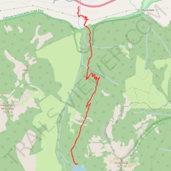
- Distance: 12.1 Km
- Elevation gain: 659 m
- Maximum elevation: 1,139 m
- Elevation loss: 658 m
- Minimum elevation: 595 m
- Moving time: 3 h 28 m
- Moving speed: 3.5 Km/h
- Maximum speed: 18.4 Km/h
- Total time: 4 h 3 m
- Global speed: 3.0 Km/h
Interactive trail map
Trail profile
- Distance: 12.1 Km
- Elevation gain: 659 m
- Maximum elevation: 1,139 m
- Elevation loss: 658 m
- Minimum elevation: 595 m
- Moving time: 3 h 28 m
- Moving speed: 3.5 Km/h
- Maximum speed: 18.4 Km/h
- Total time: 4 h 3 m
- Global speed: 3.0 Km/h
About this trail
Name: Annette Lake Trail in Mount Baker Snoqualmie National Forest trail, distance, elevation, map, profile, GPS track
Start: Annette Lake Trail, King County, Washington, United States (47.39276 -121.47402)
End: Annette Lake Trail, King County, Washington, United States (47.39268 -121.47407)
Coordinates: 47.36050 -121.47635 47.39276 -121.46771
Other hiking, mountain biking, running and outdoor activity trails
Click on a trail to view its statistics, map and profile.
Annette Lake Trail in Mount Baker-Snoqualmie National Forest
United States > Washington > King County
The Annette Lake Trail, nestled in the Mount Baker-Snoqualmie National Forest, offers a delightful hiking experience combining serene natural beauty and moderate physical challenge. The journey begins in lush, shaded forests dominated by towering evergreens and progresses past cascading waterfalls, talus…
Distance: 5.2 Km • Elevation gain: 556 m • Maximum elevation: 1,136 m
Northern part of the Pacific Crest Trail (PCT)
United States > Oregon > Klamath County
Hike on the Pacific Crest National Scenic Trail from Crater Lake to Canada Border through Oregon and Washington along the Sierra Nevada and Cascade mountain ranges. #Hiking #Mountain #SierraNevada #Cascade #Nature #Forest #Park #PCT
Distance: 1,198.3 Km • Elevation gain: 44,308 m • Maximum elevation: 2,307 m
Annette Lake Trail
United States > Washington > King County
Distance: 11.8 Km • Elevation gain: 637 m • Maximum elevation: 1,137 m