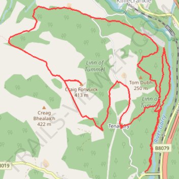
Loop run at Craig Fonvuick
- Distance: 10.3 Km
- Elevation gain: 452 m
- Maximum elevation: 404 m
- Elevation loss: 459 m
- Minimum elevation: 113 m
- Moving time: 1 h 59 m
- Moving speed: 5.1 Km/h
- Maximum speed: 28.7 Km/h
- Total time: 2 h 20 m
- Global speed: 4.4 Km/h
Interactive trail map
Trail profile
- Distance: 10.3 Km
- Elevation gain: 452 m
- Maximum elevation: 404 m
- Elevation loss: 459 m
- Minimum elevation: 113 m
- Moving time: 1 h 59 m
- Moving speed: 5.1 Km/h
- Maximum speed: 28.7 Km/h
- Total time: 2 h 20 m
- Global speed: 4.4 Km/h
About this trail
Name: Loop run at Craig Fonvuick trail, distance, elevation, map, profile, GPS track
Start: B8019, Tenandry, Perth and Kinross, Scotland, PH16 5LE, United Kingdom (56.72806 -3.77724)
Coordinates: 56.72806 -3.80178 56.74434 -3.77273
Other hiking, mountain biking, running and outdoor activity trails
Click on a trail to view its statistics, map and profile.
Loch Tummel Loop
United Kingdom > Scotland > Perth and Kinross > Pitlochry
To Escape Route Cafe UK, Perthshire, Loch Tummel
Distance: 46.3 Km • Elevation gain: 819 m • Maximum elevation: 289 m