Victoria Park Run
- Distance: 13.0 Km
- Elevation gain: 218 m
- Maximum elevation: 56 m
- Elevation loss: 216 m
- Minimum elevation: 17 m
- Moving time: 1 h 50 m
- Moving speed: 7.1 Km/h
- Maximum speed: 14.0 Km/h
- Total time: 1 h 52 m
- Global speed: 7.0 Km/h
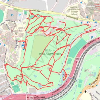
Interactive trail map
Trail profile
- Distance: 13.0 Km
- Elevation gain: 218 m
- Maximum elevation: 56 m
- Elevation loss: 216 m
- Minimum elevation: 17 m
- Moving time: 1 h 50 m
- Moving speed: 7.1 Km/h
- Maximum speed: 14.0 Km/h
- Total time: 1 h 52 m
- Global speed: 7.0 Km/h
About this trail
Name: Victoria Park Run trail, distance, elevation, map, profile, GPS track
Start: Herston Road, Herston, Greater Brisbane, Queensland, 4006, Australia (-27.44969 153.02217)
End: Herston Road, Herston, Greater Brisbane, Queensland, 4006, Australia (-27.44972 153.02150)
Coordinates: -27.45641 153.01600 -27.44862 153.02626
Topography: Queensland topographic map, elevation, terrain
Other hiking, mountain biking, running and outdoor activity trails
Click on a trail to view its statistics, map and profile.