Make a donation
Gear up for your next adventure:
As an Amazon Associate, this site earns from qualifying purchases at no extra cost to you.
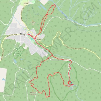
Steavenson's Falls, Keppel Lookout, Michaeldene Trail loop
- Distance: 19.8 Km
- Elevation gain: 694 m
- Maximum elevation: 837 m
- Elevation loss: 694 m
- Minimum elevation: 378 m
- Moving time: 2 h 29 m
- Moving speed: 7.9 Km/h
- Maximum speed: 19.0 Km/h
- Total time: 2 h 49 m
- Global speed: 7.0 Km/h
Interactive trail map
Make a donation
Gear up for your next adventure:
As an Amazon Associate, this site earns from qualifying purchases at no extra cost to you.
Trail profile
- Distance: 19.8 Km
- Elevation gain: 694 m
- Maximum elevation: 837 m
- Elevation loss: 694 m
- Minimum elevation: 378 m
- Moving time: 2 h 29 m
- Moving speed: 7.9 Km/h
- Maximum speed: 19.0 Km/h
- Total time: 2 h 49 m
- Global speed: 7.0 Km/h
Make a donation
Gear up for your next adventure:
As an Amazon Associate, this site earns from qualifying purchases at no extra cost to you.
About this trail
Name: Steavenson's Falls, Keppel Lookout, Michaeldene Trail loop trail, distance, elevation, map, profile, GPS track
Start: Gallipolli Park, Marysville, Shire of Murrindindi, Victoria, 3779, Australia (-37.51026 145.74861)
End: Gallipolli Park, Marysville, Shire of Murrindindi, Victoria, 3779, Australia (-37.51027 145.74853)
Coordinates: -37.53951 145.74853 -37.49643 145.77520
Topography: Victoria topographic map, elevation, terrain
Make a donation
Gear up for your next adventure:
As an Amazon Associate, this site earns from qualifying purchases at no extra cost to you.
Other hiking, mountain biking, running and outdoor activity trails
Click on a trail to view its statistics, map and profile.
Tallarook - Eildon - Hurstbridge
Australia > Victoria > Tallarook
#Bike
Distance: 278.8 Km • Elevation gain: 4,897 m • Maximum elevation: 868 m
Marysville Loop
Australia > Victoria > Marysville
Steavensons Falls Natural Features and Scenic Reserve. #Hiking #Loop #Steavensons
Distance: 13.6 Km • Elevation gain: 588 m • Maximum elevation: 837 m