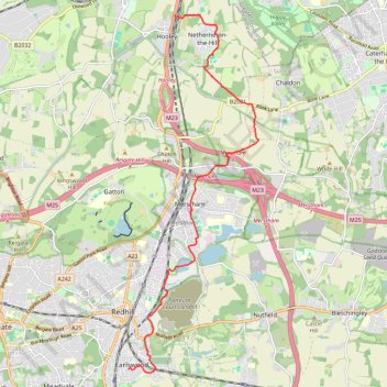
Walk Earlswood to Hooley
South Merstham, Earlswood, Alderstead Heath, Netherne, Hooley
- Distance: 12.3 Km
- Elevation gain: 208 m
- Maximum elevation: 197 m
- Elevation loss: 169 m
- Minimum elevation: 73 m
- Moving time: 3 h 1 m
- Moving speed: 4.1 Km/h
- Maximum speed: 9.9 Km/h
- Total time: 3 h 31 m
- Global speed: 3.5 Km/h
Interactive trail map
Trail profile
- Distance: 12.3 Km
- Elevation gain: 208 m
- Maximum elevation: 197 m
- Elevation loss: 169 m
- Minimum elevation: 73 m
- Moving time: 3 h 1 m
- Moving speed: 4.1 Km/h
- Maximum speed: 9.9 Km/h
- Total time: 3 h 31 m
- Global speed: 3.5 Km/h
About this trail
Name: Walk Earlswood to Hooley trail, distance, elevation, map, profile, GPS track
Coordinates: 51.22891 -0.16664 51.29643 -0.12735
Other hiking, mountain biking, running and outdoor activity trails
Click on a trail to view its statistics, map and profile.
Loop Walk Earlswood, South Nutfield, Nutfield, Nutfield Marsh, Redhill
United Kingdom > England > Surrey > Reigate and Banstead > Redhill
Distance: 14.5 Km • Elevation gain: 159 m • Maximum elevation: 145 m
Walk Nutfield Marsh to Bletchingley via Mercer's Lake and Spynes Mere in Surrey Hills National Landscape
United Kingdom > England > Surrey > Reigate and Banstead > Redhill
Distance: 7.4 Km • Elevation gain: 113 m • Maximum elevation: 153 m
Walk Redhill to Hooley via The Moors Nature Reserve, South Mertstham, Tollsworth Manor, Alderstead Heath, Netherne-on-the-Hill
United Kingdom > England > Surrey > Reigate and Banstead > Redhill
Redhill, Hooley, South Mertstham, Alderstead Heath, Netherne-on-the-Hill
Distance: 10.8 Km • Elevation gain: 149 m • Maximum elevation: 197 m
Walk Earlswood, Merstham, Chaldon church, Fartyhing Downs, Coulson
United Kingdom > England > Surrey > Reigate and Banstead > Redhill
Distance: 16.4 Km • Elevation gain: 249 m • Maximum elevation: 197 m
Walk Earlswood to North Merstham, via Nutfirld Marsh, Brewer Street, Tylers Green Godstone, Gravelly Hill, North Downs Way
United Kingdom > England > Surrey > Reigate and Banstead > Redhill
Distance: 17.0 Km • Elevation gain: 235 m • Maximum elevation: 232 m
Walk Holmethorpe, Mersers Country Park, Nutfield Marsh, Beside expanded sand quarry
United Kingdom > England > Surrey > Reigate and Banstead > Merstham
Distance: 4.4 Km • Elevation gain: 15 m • Maximum elevation: 90 m
Walk Earlswood to Nutfield March, via South Nutfield
United Kingdom > England > Surrey > Reigate and Banstead > Redhill
Distance: 11.5 Km • Elevation gain: 123 m • Maximum elevation: 145 m
Walk - Petridgewood Common, Sidlow Bridge, Earlswood Common
United Kingdom > England > Surrey > Reigate and Banstead > Salfords
Distance: 6.7 Km • Elevation gain: 59 m • Maximum elevation: 104 m
Walk on lanfilled quary land north of Nutfield Cemetery
United Kingdom > England > Surrey > South Nutfield
Distance: 3.7 Km • Elevation gain: 69 m • Maximum elevation: 133 m
Walk Colley Hill, Banstead Heath, Merstham
United Kingdom > England > Surrey > Reigate and Banstead > Reigate
Olley Hill, Banstead Heath, Merstham, Surrey
Distance: 16.9 Km • Elevation gain: 239 m • Maximum elevation: 236 m
Walk Tadworth to Merstham
United Kingdom > England > Surrey > Reigate and Banstead > Walton On The Hill
Tadworth, Banstead Heath, Lowert Kingswood, Merstham
Distance: 10.1 Km • Elevation gain: 99 m • Maximum elevation: 194 m