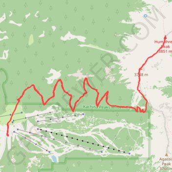
Humphreys Peak
Interactive trail map
Trail profile
- Distance: 17.0 Km
- Elevation gain: 1,028 m
- Maximum elevation: 3,834 m
- Elevation loss: 1,028 m
- Minimum elevation: 2,831 m
About this trail
Name: Humphreys Peak trail, distance, elevation, map, profile, GPS track
Start: Snow Bowl Road, Coconino County, Arizona, United States (35.32911 -111.71145)
End: Snow Bowl Road, Coconino County, Arizona, United States (35.32911 -111.71145)
Coordinates: 35.32911 -111.71188 35.34662 -111.67789
Other hiking, mountain biking, running and outdoor activity trails
Click on a trail to view its statistics, map and profile.
Humphreys Peak Trail in Kachina Peaks Wilderness
United States > Arizona > Coconino County
Humphreys Peak Trail, located in the Kachina Peaks Wilderness in Arizona, is a scenic and challenging hike that leads to the state's highest point. As the trail ascends, it traverses alpine meadows, lush forests and ancient volcanic fields, leading to a saddle that reveals panoramic views of the Inner Basin…
Distance: 16.3 Km • Elevation gain: 1,023 m • Maximum elevation: 3,834 m