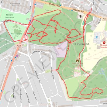
Thank you for supporting this site ❤️
Make a donation
Make a donation
Gear up for your next adventure:
As an Amazon Associate, this site earns from qualifying purchases at no extra cost to you.
Castlewood Loop
Morning Walk
- Distance: 6.2 Km
- Elevation gain: 166 m
- Maximum elevation: 122 m
- Elevation loss: 165 m
- Minimum elevation: 58 m
- Moving time: 1 h 37 m
- Moving speed: 3.8 Km/h
- Maximum speed: 7.8 Km/h
- Total time: 1 h 40 m
- Global speed: 3.7 Km/h
Interactive trail map
Thank you for supporting this site ❤️
Make a donation
Make a donation
Gear up for your next adventure:
As an Amazon Associate, this site earns from qualifying purchases at no extra cost to you.
Trail profile
- Distance: 6.2 Km
- Elevation gain: 166 m
- Maximum elevation: 122 m
- Elevation loss: 165 m
- Minimum elevation: 58 m
- Moving time: 1 h 37 m
- Moving speed: 3.8 Km/h
- Maximum speed: 7.8 Km/h
- Total time: 1 h 40 m
- Global speed: 3.7 Km/h
Thank you for supporting this site ❤️
Make a donation
Make a donation
Gear up for your next adventure:
As an Amazon Associate, this site earns from qualifying purchases at no extra cost to you.
About this trail
Name: Castlewood Loop trail, distance, elevation, map, profile, GPS track
Coordinates: 51.46382 0.05138 51.47047 0.06309
Thank you for supporting this site ❤️
Make a donation
Make a donation
Gear up for your next adventure:
As an Amazon Associate, this site earns from qualifying purchases at no extra cost to you.