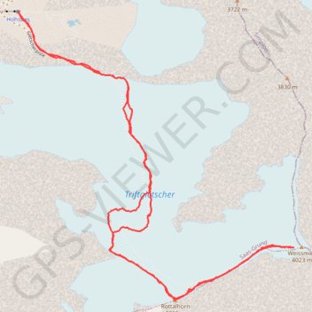
Weissmies
- Distance: 7.1 Km
- Elevation gain: 969 m
- Maximum elevation: 3,992 m
- Elevation loss: 969 m
- Minimum elevation: 3,098 m
Interactive trail map
Trail profile
- Distance: 7.1 Km
- Elevation gain: 969 m
- Maximum elevation: 3,992 m
- Elevation loss: 969 m
- Minimum elevation: 3,098 m
About this trail
Name: Weissmies trail, distance, elevation, map, profile, GPS track
End: Panoramaweg der 18 Viertausender, Saas-Grund, Visp, Wallis, 3910, Switzerland (46.13967 7.99110)
Coordinates: 46.12489 7.99110 46.13970 8.01146