Thank you for supporting this site ❤️
Make a donation
Make a donation
Gear up for your next adventure:
As an Amazon Associate, this site earns from qualifying purchases at no extra cost to you.
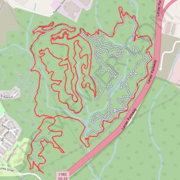
Chicopee Woods MTB Loop
Interactive trail map
Thank you for supporting this site ❤️
Make a donation
Make a donation
Gear up for your next adventure:
As an Amazon Associate, this site earns from qualifying purchases at no extra cost to you.
Trail profile
- Distance: 17.5 Km
- Elevation gain: 377 m
- Maximum elevation: 387 m
- Elevation loss: 377 m
- Minimum elevation: 324 m
- Moving time: 1 h 23 m
- Moving speed: 12.6 Km/h
- Maximum speed: 45.7 Km/h
- Total time: 1 h 23 m
- Global speed: 12.6 Km/h
Thank you for supporting this site ❤️
Make a donation
Make a donation
Gear up for your next adventure:
As an Amazon Associate, this site earns from qualifying purchases at no extra cost to you.
About this trail
Name: Chicopee Woods MTB Loop trail, distance, elevation, map, profile, GPS track
Coordinates: 34.24792 -83.83758 34.26491 -83.82221
Thank you for supporting this site ❤️
Make a donation
Make a donation
Gear up for your next adventure:
As an Amazon Associate, this site earns from qualifying purchases at no extra cost to you.