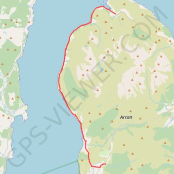
Bridgend Campsite to Lochranza and back
Arran, Scotland
- Distance: 59.2 Km
- Elevation gain: 560 m
- Maximum elevation: 59 m
- Elevation loss: 560 m
- Minimum elevation: -2 m
- Moving time: 2 h 50 m
- Moving speed: 20.9 Km/h
- Maximum speed: 41.9 Km/h
- Total time: 7 h 40 m
- Global speed: 7.7 Km/h
Interactive trail map
Trail profile
- Distance: 59.2 Km
- Elevation gain: 560 m
- Maximum elevation: 59 m
- Elevation loss: 560 m
- Minimum elevation: -2 m
- Moving time: 2 h 50 m
- Moving speed: 20.9 Km/h
- Maximum speed: 41.9 Km/h
- Total time: 7 h 40 m
- Global speed: 7.7 Km/h
About this trail
Name: Bridgend Campsite to Lochranza and back trail, distance, elevation, map, profile, GPS track
Start: The String, Pien, Shiskine, North Ayrshire, Scotland, KA27 8DT, United Kingdom (55.52316 -5.29605)
End: The String, Pien, Shiskine, North Ayrshire, Scotland, KA27 8DT, United Kingdom (55.52316 -5.29610)
Coordinates: 55.51811 -5.39442 55.70758 -5.27619
Other hiking, mountain biking, running and outdoor activity trails
Click on a trail to view its statistics, map and profile.
King's Cave (Walk)
United Kingdom > Scotland > North Ayrshire > Torbeg
Arran, Scotland
Distance: 6.2 Km • Elevation gain: 182 m • Maximum elevation: 77 m