Make a donation
Gear up for your next adventure:
As an Amazon Associate, this site earns from qualifying purchases at no extra cost to you.
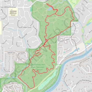
Sope Creek MTB Loop
Mountain Bike loop on Sope Creek Trails in Chattahoochee River National Recreation Area. #MTB #Loop #River #Forest #Nature
- Distance: 10.4 Km
- Elevation gain: 211 m
- Maximum elevation: 313 m
- Elevation loss: 211 m
- Minimum elevation: 252 m
- Moving time: 55 m 24 s
- Moving speed: 11.2 Km/h
- Maximum speed: 50.7 Km/h
- Total time: 55 m 24 s
- Global speed: 11.2 Km/h
Interactive trail map
Make a donation
Gear up for your next adventure:
As an Amazon Associate, this site earns from qualifying purchases at no extra cost to you.
Trail profile
- Distance: 10.4 Km
- Elevation gain: 211 m
- Maximum elevation: 313 m
- Elevation loss: 211 m
- Minimum elevation: 252 m
- Moving time: 55 m 24 s
- Moving speed: 11.2 Km/h
- Maximum speed: 50.7 Km/h
- Total time: 55 m 24 s
- Global speed: 11.2 Km/h
Make a donation
Gear up for your next adventure:
As an Amazon Associate, this site earns from qualifying purchases at no extra cost to you.
About this trail
Name: Sope Creek MTB Loop trail, distance, elevation, map, profile, GPS track
Start: Sope Creek, Sibley Forest, Cobb County, Georgia, 30000, United States (33.93787 -84.44253)
End: Sope Creek, Sibley Forest, Cobb County, Georgia, 30000, United States (33.93785 -84.44254)
Coordinates: 33.91601 -84.45136 33.93787 -84.43397
Make a donation
Gear up for your next adventure:
As an Amazon Associate, this site earns from qualifying purchases at no extra cost to you.