Afternoon hike at Lake Wilson Loop Trail
Wilson Lake
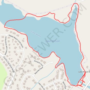
- Distance: 4.0 Km
- Elevation gain: 36 m
- Maximum elevation: 44 m
- Elevation loss: 35 m
- Minimum elevation: 34 m
- Moving time: 44 m 40 s
- Moving speed: 5.4 Km/h
- Maximum speed: 17.8 Km/h
- Total time: 44 m 40 s
- Global speed: 5.4 Km/h
Interactive trail map
Trail profile
- Distance: 4.0 Km
- Elevation gain: 36 m
- Maximum elevation: 44 m
- Elevation loss: 35 m
- Minimum elevation: 34 m
- Moving time: 44 m 40 s
- Moving speed: 5.4 Km/h
- Maximum speed: 17.8 Km/h
- Total time: 44 m 40 s
- Global speed: 5.4 Km/h
About this trail
Name: Afternoon hike at Lake Wilson Loop Trail trail, distance, elevation, map, profile, GPS track
Start: Lake Wilson Loop, Wilson, Wilson County, North Carolina, United States (35.78910 -77.92008)
End: Lake Wilson Loop, Wilson, Wilson County, North Carolina, United States (35.78901 -77.91993)
Coordinates: 35.78852 -77.92936 35.79657 -77.91970
Other hiking, mountain biking, running and outdoor activity trails
Click on a trail to view its statistics, map and profile.
Lake Wilson Loop Trail
United States > North Carolina > Wilson County > Wilson
Distance: 3.7 Km • Elevation gain: 38 m • Maximum elevation: 47 m