Thank you for supporting this site ❤️
Make a donation
Make a donation
Gear up for your next adventure:
As an Amazon Associate, this site earns from qualifying purchases at no extra cost to you.
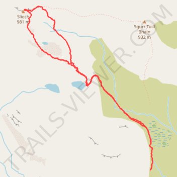
Walk up Slioch
- Distance: 6.0 Km
- Elevation gain: 470 m
- Maximum elevation: 972 m
- Elevation loss: 558 m
- Minimum elevation: 427 m
- Moving time: 1 h 59 m
- Moving speed: 3.0 Km/h
- Maximum speed: 7.3 Km/h
- Total time: 2 h 30 m
- Global speed: 2.4 Km/h
Interactive trail map
Thank you for supporting this site ❤️
Make a donation
Make a donation
Gear up for your next adventure:
As an Amazon Associate, this site earns from qualifying purchases at no extra cost to you.
Trail profile
- Distance: 6.0 Km
- Elevation gain: 470 m
- Maximum elevation: 972 m
- Elevation loss: 558 m
- Minimum elevation: 427 m
- Moving time: 1 h 59 m
- Moving speed: 3.0 Km/h
- Maximum speed: 7.3 Km/h
- Total time: 2 h 30 m
- Global speed: 2.4 Km/h
Thank you for supporting this site ❤️
Make a donation
Make a donation
Gear up for your next adventure:
As an Amazon Associate, this site earns from qualifying purchases at no extra cost to you.
About this trail
Name: Walk up Slioch trail, distance, elevation, map, profile, GPS track
Start: Coire an Tuill Bhain, Highland, Scotland, United Kingdom (57.65328 -5.32220)
End: Coire an Tuill Bhain, Highland, Scotland, United Kingdom (57.65045 -5.32241)
Coordinates: 57.65045 -5.34707 57.66755 -5.32187
Thank you for supporting this site ❤️
Make a donation
Make a donation
Gear up for your next adventure:
As an Amazon Associate, this site earns from qualifying purchases at no extra cost to you.