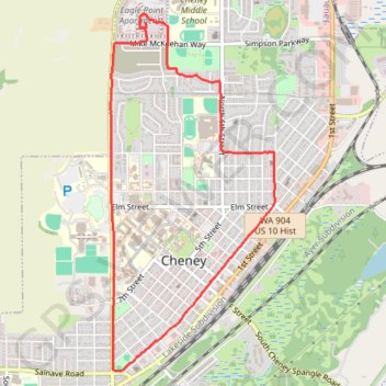
2016-08-22 20:01:30
- Distance: 7.1 Km
- Elevation gain: 51 m
- Maximum elevation: 766 m
- Elevation loss: 51 m
- Minimum elevation: 718 m
- Moving time: 1 h 4 m
- Moving speed: 6.5 Km/h
- Maximum speed: 8.8 Km/h
- Total time: 1 h 21 m
- Global speed: 5.2 Km/h
Interactive trail map
Trail profile
- Distance: 7.1 Km
- Elevation gain: 51 m
- Maximum elevation: 766 m
- Elevation loss: 51 m
- Minimum elevation: 718 m
- Moving time: 1 h 4 m
- Moving speed: 6.5 Km/h
- Maximum speed: 8.8 Km/h
- Total time: 1 h 21 m
- Global speed: 5.2 Km/h
About this trail
Name: 2016-08-22 20:01:30 trail, distance, elevation, map, profile, GPS track
Start: 1090, West Betz Road, Cheney, Spokane County, Washington, 99004, United States (47.50467 -117.58317)
End: 1090, West Betz Road, Cheney, Spokane County, Washington, 99004, United States (47.50461 -117.58315)
Coordinates: 47.48179 -117.58649 47.50553 -117.57029