Make a donation
Gear up for your next adventure:
As an Amazon Associate, this site earns from qualifying purchases at no extra cost to you.
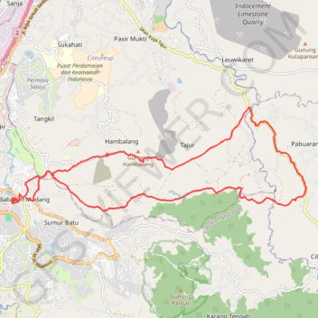
Bogor Trail Run
- Distance: 29.6 Km
- Elevation gain: 968 m
- Maximum elevation: 546 m
- Elevation loss: 975 m
- Minimum elevation: 183 m
- Moving time: 5 h 42 m
- Moving speed: 5.2 Km/h
- Maximum speed: 13.5 Km/h
- Total time: 6 h 23 m
- Global speed: 4.6 Km/h
Interactive trail map
Make a donation
Gear up for your next adventure:
As an Amazon Associate, this site earns from qualifying purchases at no extra cost to you.
Trail profile
- Distance: 29.6 Km
- Elevation gain: 968 m
- Maximum elevation: 546 m
- Elevation loss: 975 m
- Minimum elevation: 183 m
- Moving time: 5 h 42 m
- Moving speed: 5.2 Km/h
- Maximum speed: 13.5 Km/h
- Total time: 6 h 23 m
- Global speed: 4.6 Km/h
Make a donation
Gear up for your next adventure:
As an Amazon Associate, this site earns from qualifying purchases at no extra cost to you.
About this trail
Name: Bogor Trail Run trail, distance, elevation, map, profile, GPS track
Coordinates: -6.56775 106.86032 -6.53608 106.95035
Make a donation
Gear up for your next adventure:
As an Amazon Associate, this site earns from qualifying purchases at no extra cost to you.
Other hiking, mountain biking, running and outdoor activity trails
Click on a trail to view its statistics, map and profile.
Ciputat Market to Penginapan Pondok Indah Karang Potong
Indonesia > Banten > South Tangerang
Distance: 277.2 Km • Elevation gain: 4,960 m • Maximum elevation: 790 m
Rute dari Kantor Pusat Direktorat Jenderal Pajak, Jalan Gatot Subroto, RT.7/RW.1, Senayan, Kota Jakarta Selatan, Daerah Khusus I
Indonesia > Special capital Region of Jakarta
Distance: 55.6 Km • Elevation gain: 441 m • Maximum elevation: 272 m