
East Coast Greenway from Perryville to Newark
Starting in Perryville, this East Coast Greenway ride follows the head of the Chesapeake Bay past Furnace Bay and the historic Principio Furnace area, then rolls through Charlestown toward the waterfront town of North East and the North East River.
From North East, the route turns inland through Elk Neck State Forest, where forest roads, mixed woodland, native shrubs, seasonal birdlife, and quiet creekside passages shape the ride before it approaches Elk Landing and Elkton.
Beyond Elkton, the route follows the Big Elk Creek corridor and the Elkton Road approach toward Newark, linking town parks, suburban edges, and the Delaware East Coast Greenway network for a varied ride between bay country, forest, creek valleys, and urban trail connections.
#Bike #Cycling #ECG #Forest #Creek #Nature #River
- Distance: 40.9 Km
- Elevation gain: 403 m
- Maximum elevation: 60 m
- Elevation loss: 378 m
- Minimum elevation: 0 m
Interactive trail map
Trail profile
- Distance: 40.9 Km
- Elevation gain: 403 m
- Maximum elevation: 60 m
- Elevation loss: 378 m
- Minimum elevation: 0 m
About this trail
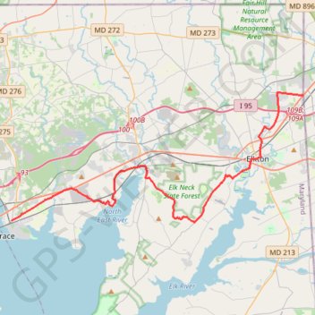
Name: East Coast Greenway from Perryville to Newark trail, distance, elevation, map, profile, GPS track
Start: Aiken Avenue, Concord, Perryville, Cecil County, Maryland, 21902, United States (39.56014 -76.07127)
End: Elkton Road, Newark, New Castle County, Delaware, 19711, United States (39.65396 -75.78889)
Coordinates: 39.55893 -76.07127 39.65622 -75.78889