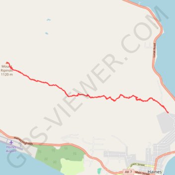
Mount Ripinski Hike in Haines Alaska USA
- Distance: 13.4 Km
- Elevation gain: 989 m
- Maximum elevation: 1,119 m
- Elevation loss: 989 m
- Minimum elevation: 144 m
- Moving time: 5 h 33 m
- Moving speed: 2.4 Km/h
- Maximum speed: 11.4 Km/h
- Total time: 7 h 19 m
- Global speed: 1.8 Km/h
Interactive trail map
Trail profile
- Distance: 13.4 Km
- Elevation gain: 989 m
- Maximum elevation: 1,119 m
- Elevation loss: 989 m
- Minimum elevation: 144 m
- Moving time: 5 h 33 m
- Moving speed: 2.4 Km/h
- Maximum speed: 11.4 Km/h
- Total time: 7 h 19 m
- Global speed: 1.8 Km/h
About this trail
Name: Mount Ripinski Hike in Haines Alaska USA trail, distance, elevation, map, profile, GPS track
Start: 1093, Young Road, Haines, Alaska, 99827, United States (59.25114 -135.43799)
End: 1093, Young Road, Haines, Alaska, 99827, United States (59.25120 -135.43801)
Coordinates: 59.25113 -135.52026 59.26428 -135.43799