Colchuck Lake Trail in Okanogan-Wenatchee National Forest
The Colchuck Lake Trail is a delightful hike that leads you to one of the most stunning alpine lakes in Washington. Starting off with a gentle climb through lush forests, the trail gradually transforms into rocky terrain, offering breathtaking views of the towering Dragontail and Colchuck Peaks as you near the lake. The sight of the crystal-clear aquamarine waters framed by granite cliffs is truly a rewarding experience, making this trail perfect for both day hikes and overnight camping adventures. #Hiking #Mountain #Lake #Forest #Nature
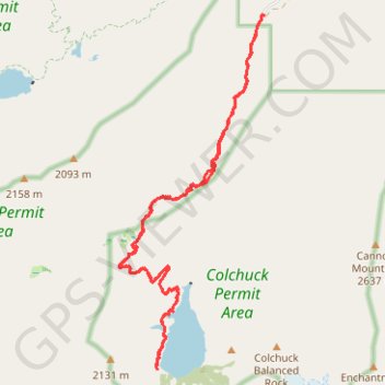
- Distance: 15.4 Km
- Elevation gain: 724 m
- Maximum elevation: 1,718 m
- Elevation loss: 724 m
- Minimum elevation: 1,035 m
- Moving time: 5 h 17 m
- Moving speed: 2.9 Km/h
- Maximum speed: 9.4 Km/h
- Total time: 6 h 31 m
- Global speed: 2.4 Km/h
Interactive trail map
Trail profile
- Distance: 15.4 Km
- Elevation gain: 724 m
- Maximum elevation: 1,718 m
- Elevation loss: 724 m
- Minimum elevation: 1,035 m
- Moving time: 5 h 17 m
- Moving speed: 2.9 Km/h
- Maximum speed: 9.4 Km/h
- Total time: 6 h 31 m
- Global speed: 2.4 Km/h
About this trail
Name: Colchuck Lake Trail in Okanogan-Wenatchee National Forest trail, distance, elevation, map, profile, GPS track
Coordinates: 47.48880 -120.84409 47.52799 -120.82040
Other hiking, mountain biking, running and outdoor activity trails
Click on a trail to view its statistics, map and profile.
The Enchantments
United States > Washington > Chelan County
From the Stuart Lake Trail, the route enters the Alpine Lakes Wilderness through forest, creek crossings, and gradually rougher alpine terrain before reaching Colchuck Lake, a striking first landmark set below Colchuck Peak and Dragontail Peak, with Aasgard Pass rising steeply above the far shore as the…
Distance: 29.2 Km • Elevation gain: 1,502 m • Maximum elevation: 2,383 m
Cashmere Mountain via Little Eightmile Lake, Eightmile-Trout Creek Trail, Lake Caroline and Windy Pass
United States > Washington > Chelan County
The hike to Cashmere Mountain is a spectacular journey through the heart of the Alpine Lakes Wilderness, offering a diverse range of views. Starting at the Eightmile Lake Trailhead, the route leads you past scenic lakes like Little Eightmile Lake and Lake Caroline, each with pristine alpine waters framed by…
Distance: 15.3 Km • Elevation gain: 1,677 m • Maximum elevation: 2,510 m
Colchuck Lake via Stuart Lake Trail and Colchuck Lake Trail in Alpine Lakes Wilderness
United States > Washington > Chelan County
The Colchuck Lake hike offers a challenging yet incredibly rewarding adventure through Washington's rugged Alpine Lakes Wilderness. As you ascend, the trail meanders through dense forests and rocky terrain, with spectacular views opening up toward Dragontail Peak and the Colchuck Glacier. The final…
Distance: 12.9 Km • Elevation gain: 709 m • Maximum elevation: 1,703 m
Lake Stuart via Stuart Lake Trail in Alpine Lakes Wilderness
United States > Washington > Chelan County
The hike to Lake Stuart in the Alpine Lakes Wilderness offers a serene journey through lush forests, alongside Mountaineer Creek, and past impressive glacial boulders. The route gradually transitions from shaded woodland paths to expansive meadows that unveil stunning views of Mount Stuart towering above the…
Distance: 6.6 Km • Elevation gain: 538 m • Maximum elevation: 1,560 m
Northern part of the Pacific Crest Trail (PCT)
United States > Oregon > Klamath County
Hike on the Pacific Crest National Scenic Trail from Crater Lake to Canada Border through Oregon and Washington along the Sierra Nevada and Cascade mountain ranges. #Hiking #Mountain #SierraNevada #Cascade #Nature #Forest #Park #PCT
Distance: 1,198.3 Km • Elevation gain: 44,308 m • Maximum elevation: 2,307 m
Enchantments traverse
United States > Washington > Chelan County
Distance: 32.7 Km • Elevation gain: 1,559 m • Maximum elevation: 2,383 m
Enchantmentpeak on GPSies.com
United States > Washington > Chelan County
Distance: 12.3 Km • Elevation gain: 1,777 m • Maximum elevation: 2,572 m