
Williams Lake Trail in Carson National Forest
The Williams Lake Trail offers an enchanting hiking experience that showcases the beauty of northern New Mexico. As you navigate the route, you'll be surrounded by lush Engelmann spruce trees and wildflower meadows, all while enjoying stunning views of the Sangre de Cristo Mountains and the picturesque Williams Lake nestled at the trail's end. The peaceful ambiance, coupled with opportunities to spot local wildlife and marvel at the rugged terrain, makes this hike a delightful escape into nature. #Hiking #Mountain #Lake #Forest #Nature
- Distance: 7.0 Km
- Elevation gain: 326 m
- Maximum elevation: 3,397 m
- Elevation loss: 325 m
- Minimum elevation: 3,105 m
- Moving time: 2 h 16 m
- Moving speed: 3.1 Km/h
- Maximum speed: 5.8 Km/h
- Total time: 5 h 35 m
- Global speed: 1.3 Km/h
Interactive trail map
Trail profile
- Distance: 7.0 Km
- Elevation gain: 326 m
- Maximum elevation: 3,397 m
- Elevation loss: 325 m
- Minimum elevation: 3,105 m
- Moving time: 2 h 16 m
- Moving speed: 3.1 Km/h
- Maximum speed: 5.8 Km/h
- Total time: 5 h 35 m
- Global speed: 1.3 Km/h
About this trail
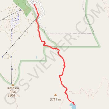
Name: Williams Lake Trail in Carson National Forest trail, distance, elevation, map, profile, GPS track
Coordinates: 36.55696 -105.44016 36.57946 -105.42903
Other hiking, mountain biking, running and outdoor activity trails
Click on a trail to view its statistics, map and profile.
Wheeler Peak Summit Trail via Williams Lake Trail in Wheeler Peak Wilderness
United States > New Mexico > Taos County > Taos Ski Valley
The Wheeler Peak Summit Trail offers an invigorating and scenic journey through the rugged terrain of the Sangre de Cristo Mountains. Starting with lush forests and alpine meadows, hikers are gradually rewarded with expansive views of Williams Lake and the surrounding wilderness before tackling the challenging…
Distance: 6.6 Km • Elevation gain: 883 m • Maximum elevation: 3,984 m
Wheeler Peak Summit via Williams Lake Trail in Carson National Forest
United States > New Mexico > Taos County > Taos Ski Valley
The hike to Wheeler Peak Summit offers an exhilarating adventure through stunning landscapes. As you ascend, you'll be greeted by vibrant wildflowers, lush forests, and the serene beauty of Williams Lake, which can be mesmerizing when frozen in early spring. The final stretch reveals breathtaking panoramic…
Distance: 13.8 Km • Elevation gain: 904 m • Maximum elevation: 3,993 m