Thank you for supporting this site ❤️
Make a donation
Make a donation
Gear up for your next adventure:
🧦Merino Wool Hiking Socks - Moisture-wicking socks to prevent blisters during long topographic surveys
As an Amazon Associate, this site earns from qualifying purchases at no extra cost to you.
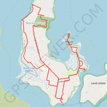
Macleay Island Loop
- Distance: 18.3 Km
- Elevation gain: 201 m
- Maximum elevation: 29 m
- Elevation loss: 184 m
- Minimum elevation: 0 m
- Moving time: 1 h 48 m
- Moving speed: 10.1 Km/h
- Maximum speed: 18.5 Km/h
- Total time: 1 h 51 m
- Global speed: 9.9 Km/h
Interactive trail map
Thank you for supporting this site ❤️
Make a donation
Make a donation
Gear up for your next adventure:
🧦Merino Wool Hiking Socks - Moisture-wicking socks to prevent blisters during long topographic surveys
As an Amazon Associate, this site earns from qualifying purchases at no extra cost to you.
Trail profile
- Distance: 18.3 Km
- Elevation gain: 201 m
- Maximum elevation: 29 m
- Elevation loss: 184 m
- Minimum elevation: 0 m
- Moving time: 1 h 48 m
- Moving speed: 10.1 Km/h
- Maximum speed: 18.5 Km/h
- Total time: 1 h 51 m
- Global speed: 9.9 Km/h
Thank you for supporting this site ❤️
Make a donation
Make a donation
Gear up for your next adventure:
As an Amazon Associate, this site earns from qualifying purchases at no extra cost to you.
About this trail
Name: Macleay Island Loop trail, distance, elevation, map, profile, GPS track
Start: Brighton Road, Macleay Island, Greater Brisbane, Queensland, 4184, Australia (-27.63114 153.36557)
Coordinates: -27.63114 153.34958 -27.59636 153.37466
Topography: Queensland topographic map, elevation, terrain
Thank you for supporting this site ❤️
Make a donation
Make a donation
Gear up for your next adventure:
As an Amazon Associate, this site earns from qualifying purchases at no extra cost to you.