King's Chair Overlook via Red and Blue Trails in Oak Mountain State Park
The King's Chair Overlook hike offers hikers an opportunity to experience stunning panoramic views of the surrounding landscapes, especially to the south of Birmingham. The route is characterized by a moderate difficulty, with a steep initial climb that gives way to more manageable terrain, rewarding visitors with breathtaking vistas from a rocky outcrop known as the King's Chair. #Hiking #Mountain #Rock #Overlook #Forest #Nature
- Distance: 5.5 Km
- Elevation gain: 188 m
- Maximum elevation: 349 m
- Elevation loss: 190 m
- Minimum elevation: 188 m
- Moving time: 1 h 19 m
- Moving speed: 4.1 Km/h
- Maximum speed: 8.3 Km/h
- Total time: 1 h 35 m
- Global speed: 3.5 Km/h
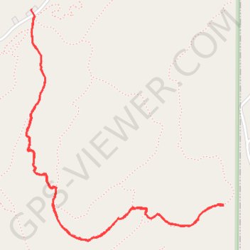
Interactive trail map
Trail profile
- Distance: 5.5 Km
- Elevation gain: 188 m
- Maximum elevation: 349 m
- Elevation loss: 190 m
- Minimum elevation: 188 m
- Moving time: 1 h 19 m
- Moving speed: 4.1 Km/h
- Maximum speed: 8.3 Km/h
- Total time: 1 h 35 m
- Global speed: 3.5 Km/h
About this trail
Name: King's Chair Overlook via Red and Blue Trails in Oak Mountain State Park trail, distance, elevation, map, profile, GPS track
Start: North Lakes Connector Trail, Pelham, Shelby County, Alabama, United States (33.35730 -86.70482)
End: North Trailhead Parking, Blue, Pelham, Shelby County, Alabama, United States (33.35769 -86.70498)
Coordinates: 33.34528 -86.70533 33.35769 -86.69266
Other hiking, mountain biking, running and outdoor activity trails
Click on a trail to view its statistics, map and profile.
King's Chair Overlook Loop from North Trailhead via Red Road and Blue Trail
United States > Alabama > Shelby County > Pelham
The King's Chair Overlook Loop is a rewarding hike that leads to one of the Oak Mountain State Park's most iconic views. As you navigate the Red Road and Blue Trail, you'll pass through lush hardwood forests and rocky terrain, with occasional glimpses of the park’s expansive vistas. The final destination,…
Distance: 7.5 Km • Elevation gain: 234 m • Maximum elevation: 349 m