Acle town
walking, acle
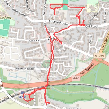
- Distance: 3.9 Km
- Elevation gain: 25 m
- Maximum elevation: 12 m
- Elevation loss: 26 m
- Minimum elevation: 3 m
- Moving time: 1 h 13 m
- Moving speed: 3.2 Km/h
- Maximum speed: 12.6 Km/h
- Total time: 1 h 23 m
- Global speed: 2.8 Km/h
Interactive trail map
Trail profile
- Distance: 3.9 Km
- Elevation gain: 25 m
- Maximum elevation: 12 m
- Elevation loss: 26 m
- Minimum elevation: 3 m
- Moving time: 1 h 13 m
- Moving speed: 3.2 Km/h
- Maximum speed: 12.6 Km/h
- Total time: 1 h 23 m
- Global speed: 2.8 Km/h
About this trail
Name: Acle town trail, distance, elevation, map, profile, GPS track
Start: 2, The Street, Acle, Broadland, Norfolk, England, NR13 3QT, United Kingdom (52.64029 1.54722)
End: Bridewell Lane, Acle, Broadland, Norfolk, England, NR13 3RA, United Kingdom (52.64128 1.54847)
Coordinates: 52.63364 1.54412 52.64216 1.55276