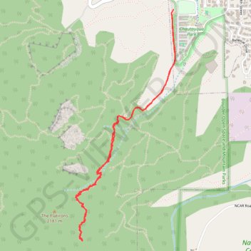
Royal Arch via Bluebell Hiking Trail, Royal Arch Trail and The Flatirons
The Royal Arch Trail in Boulder offers a rewarding hike that leads you through a scenic forest with glimpses of the iconic Flatirons. While the ascent involves quite a few stairs, the effort pays off when you reach the stunning Royal Arch, where you can soak in this impressive rock formation up close. #Hiking #Mountain #Forest #Nature #Rock
- Distance: 5.8 Km
- Elevation gain: 386 m
- Maximum elevation: 2,105 m
- Elevation loss: 384 m
- Minimum elevation: 1,733 m
- Moving time: 2 h 1 m
- Moving speed: 2.9 Km/h
- Maximum speed: 11.6 Km/h
- Total time: 2 h 57 m
- Global speed: 2.0 Km/h
Interactive trail map
Trail profile
- Distance: 5.8 Km
- Elevation gain: 386 m
- Maximum elevation: 2,105 m
- Elevation loss: 384 m
- Minimum elevation: 1,733 m
- Moving time: 2 h 1 m
- Moving speed: 2.9 Km/h
- Maximum speed: 11.6 Km/h
- Total time: 2 h 57 m
- Global speed: 2.0 Km/h
About this trail
Name: Royal Arch via Bluebell Hiking Trail, Royal Arch Trail and The Flatirons trail, distance, elevation, map, profile, GPS track
Coordinates: 39.98190 -105.29213 39.99902 -105.28253
Other hiking, mountain biking, running and outdoor activity trails
Click on a trail to view its statistics, map and profile.
Chautauqua, Bluebell-Baird and Bluebell Mesa Trails Loop in Boulder Open Space and Mountain Parks
United States > Colorado > Boulder County > Boulder
The Chautauqua, Bluebell-Baird, and Bluebell Mesa Trails Loop offers a scenic and diverse hiking experience near Boulder, Colorado. The route provides striking views of the Flatirons towering above open meadows and lush woodlands, while winding through shaded ponderosa pine forests and quiet meadows. Along the…
Distance: 2.4 Km • Elevation gain: 147 m • Maximum elevation: 1,883 m
Chautauqua Trail in City of Boulder Open Space and Mountain Parks
United States > Colorado > Boulder County > Boulder
The Chautauqua Trail in Boulder, Colorado, offers a classic introduction to the city's beloved Flatirons. Starting at the historic Chautauqua Park, the trail ascends through a mix of open meadows and shaded pine forests, providing hikers with sweeping views of Boulder, the plains, and the towering rock…
Distance: 2.1 Km • Elevation gain: 146 m • Maximum elevation: 1,883 m
Flagstaff Mountain Loop via Gregory Canyon Trail, Range View Trail and Flagstaff Trail
United States > Colorado > Boulder County
The Flagstaff Mountain Loop offers a memorable hiking experience within Boulder’s iconic foothills. Along the route, hikers are treated to sweeping views of the Flatirons, the city of Boulder below, and lush forested areas, especially as the trail ascends towards Flagstaff Mountain. The diverse scenery…
Distance: 6.5 Km • Elevation gain: 377 m • Maximum elevation: 2,117 m