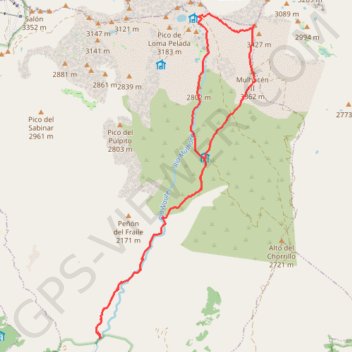
Ascent of Mulhacén from Capileira staying at Refugio Poqueira
- Distance: 21.2 Km
- Elevation gain: 2,063 m
- Maximum elevation: 3,471 m
- Elevation loss: 2,060 m
- Minimum elevation: 1,546 m
Interactive trail map
Trail profile
- Distance: 21.2 Km
- Elevation gain: 2,063 m
- Maximum elevation: 3,471 m
- Elevation loss: 2,060 m
- Minimum elevation: 1,546 m
About this trail
Name: Ascent of Mulhacén from Capileira staying at Refugio Poqueira trail, distance, elevation, map, profile, GPS track
Coordinates: 36.99240 -3.35004 37.05560 -3.31125
Other hiking, mountain biking, running and outdoor activity trails
Click on a trail to view its statistics, map and profile.
Southern section — European Divide Trail
France > Auvergne-Rhône-Alpes > Drôme > Valence
Distance: 2,423.8 Km • Elevation gain: 42,375 m • Maximum elevation: 2,005 m
Sierra nevada - Mulhacen
Spain > Andalusia > Comarca de la Alpujarra Granadina > Capileira
Distance: 17.2 Km • Elevation gain: 1,010 m • Maximum elevation: 3,472 m