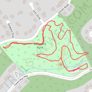
Thank you for supporting this site ❤️
Make a donation
Make a donation
Gear up for your next adventure:
As an Amazon Associate, this site earns from qualifying purchases at no extra cost to you.
Sargeant Park
- Distance: 1.8 Km
- Elevation gain: 27 m
- Maximum elevation: 230 m
- Elevation loss: 31 m
- Minimum elevation: 208 m
- Moving time: 33 m 25 s
- Moving speed: 3.3 Km/h
- Maximum speed: 6.0 Km/h
- Total time: 48 m 10 s
- Global speed: 2.3 Km/h
Interactive trail map
Thank you for supporting this site ❤️
Make a donation
Make a donation
Gear up for your next adventure:
As an Amazon Associate, this site earns from qualifying purchases at no extra cost to you.
Trail profile
- Distance: 1.8 Km
- Elevation gain: 27 m
- Maximum elevation: 230 m
- Elevation loss: 31 m
- Minimum elevation: 208 m
- Moving time: 33 m 25 s
- Moving speed: 3.3 Km/h
- Maximum speed: 6.0 Km/h
- Total time: 48 m 10 s
- Global speed: 2.3 Km/h
Thank you for supporting this site ❤️
Make a donation
Make a donation
Gear up for your next adventure:
As an Amazon Associate, this site earns from qualifying purchases at no extra cost to you.
About this trail
Name: Sargeant Park trail, distance, elevation, map, profile, GPS track
Coordinates: 39.10224 -84.46450 39.10427 -84.46009
Thank you for supporting this site ❤️
Make a donation
Make a donation
Gear up for your next adventure:
As an Amazon Associate, this site earns from qualifying purchases at no extra cost to you.